Important
Please read the "CHANGES" file for a summary of changes in this release.
This is a repository for a customized Cloud Model 1 (CM1). This custom version of CM1 was originally sourced from version 21.0 and downloaded at https://www2.mmm.ucar.edu/people/bryan/cm1/. The customizations included here are available in case anyone might find them useful.
With the help of a new file parcel_list.dat, the user can specify
the locations and times from which to release passively traced
parcels during model integration.
In the output parcel file, a new field representing the time of parcel release,
rtime, has been added.
A new file in the run directory, parcel_list.dat, can be used to
specify initial positions (x, y, and z) and release times (t) for a list of parcels.
The file should be structured in this way,
with a header (first) line followed by lines describing each parcel's initial
position and release time:
  x(m)      y(m)      z(m)      t(s)
  1000.0    1000.0    200.0     0.0
  1000.0    1000.0    200.0     3600.0
  12345.0   0.0       111.0     7200.0
  [ ... more (x,y,z,t) lines here ... ]
The subroutine that reads the parcel_list.dat file will
skip past the header line, and then read the rest of the
file line-by-line, with each line describing a parcel's initial
position and time of release.
Aside from setting up the parcel_list.dat file in the run directory,
the user must go into the namelist.input file and set iprcl=2 in the ¶m2 block.
The user should make additional adjustments to namelist.input as
would be done normally, including setting nparcels equal to the number
of parcels to track (i.e., the number of parcels described in the parcel_list.dat file).
Note that the user can still use the original method to initialize parcel trajectories
by setting iprcl=1 in namelist.input.
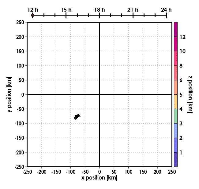
Below is an animation of parcel trajectories released hourly between 12 and 24 hours (h)
from the same spatial coordinates (enclosed in a black polygon in quadrant 3) in a low-resolution hurricane simulation.
Released parcel paths from the previous 45 minutes are shown and shaded by elevation.
A timeline is shown at the top, and the circle on the timeline marks the time in the simulation.
The circle on the timeline flickers dark red when parcels are released. The run directory used
for this simulation can be found in the example_01 branch.
- Output failures occur when setting
ipbl=5andprcl_tke=1innamelist.input. Note that these failures occur whetheriprcl=1(original design) oriprcl=2(new design).
©2022 - University Corporation for Atmospheric Research
Permission is hereby granted, free of charge, to any person obtaining a copy of this software and associated documentation files (the "Software"), to deal in the Software without restriction, including without limitation the rights to use, copy, modify, merge, publish, distribute, sublicense, and/or sell copies of the Software, and to permit persons to whom the Software is furnished to do so, subject to the following conditions:
The above copyright notice and this permission notice shall be included in all copies or substantial portions of the Software.
THE SOFTWARE IS PROVIDED "AS IS", WITHOUT WARRANTY OF ANY KIND, EXPRESS OR IMPLIED, INCLUDING BUT NOT LIMITED TO THE WARRANTIES OF MERCHANTABILITY, FITNESS FOR A PARTICULAR PURPOSE AND NONINFRINGEMENT. IN NO EVENT SHALL THE AUTHORS OR COPYRIGHT HOLDERS BE LIABLE FOR ANY CLAIM, DAMAGES OR OTHER LIABILITY, WHETHER IN AN ACTION OF CONTRACT, TORT OR OTHERWISE, ARISING FROM, OUT OF OR IN CONNECTION WITH THE SOFTWARE OR THE USE OR OTHER DEALINGS IN THE SOFTWARE.