By Rowan van der Kaaden
GIS buffer analysis is a spatial analysis technique used to create buffers around spatial features. A buffer is a defined area around a geographic object, such as a point, line, or polygon, that represents a specific distance or range - or zones that represent the proximity to the feature. The buffer can be created by measuring a fixed distance from the object or by using other criteria, such as travel time.
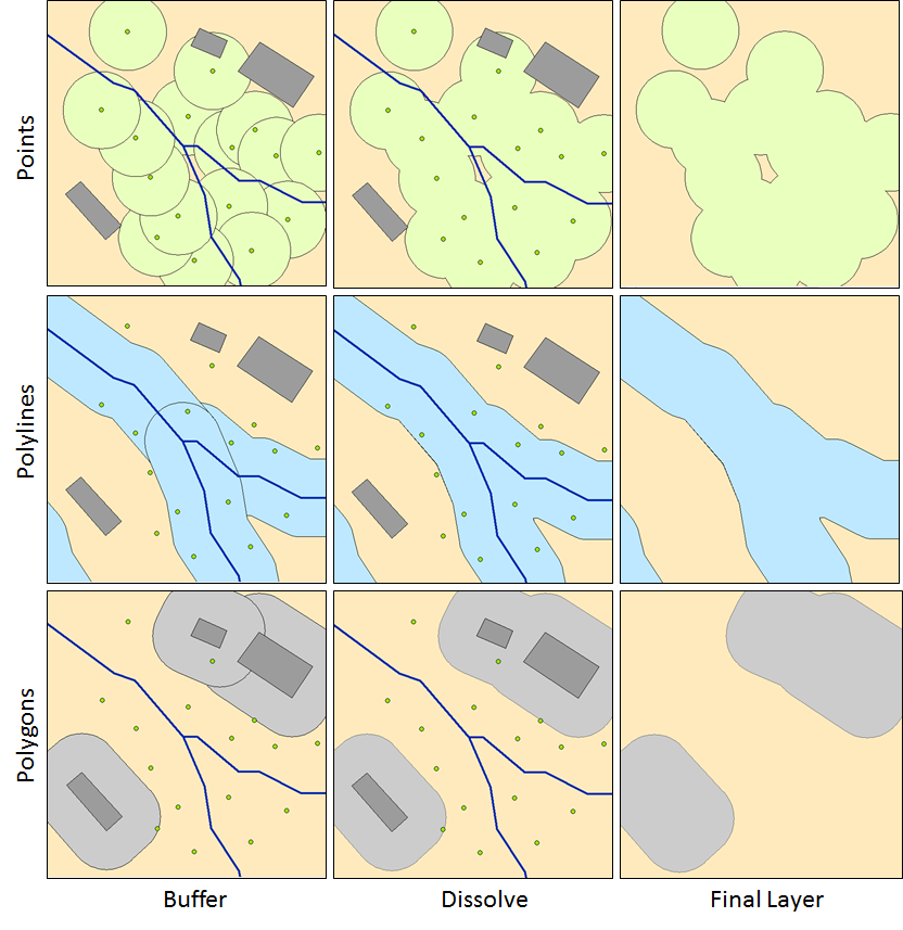
Buffer analysis is commonly used in GIS to answer questions about spatial relationships and proximity. By creating buffers around specific features, analysts can determine which other features fall within or intersect those buffers. This can be helpful in various applications, including urban planning, environmental impact assessment, transportation analysis, and emergency response planning.
The process of buffer analysis involves the following steps:
 Buffer analysis can be performed using GIS software, which provides tools and functions for creating buffers and analyzing the spatial relationships. The specific capabilities and options for buffer analysis may vary depending on the GIS software being used.
GIS overlay analysis, also known as spatial overlay analysis, is a technique used in GIS to combine multiple spatial datasets to derive new information and gain insights about their spatial relationships. Overlay analysis involves overlaying multiple layers or maps to create a composite map that integrates the attributes and geometry of the input datasets.
The overlay analysis process involves the following steps:

Overlay analysis is a powerful tool in GIS because it allows the combination and integration of multiple datasets to generate new information and support decision-making processes. It is commonly used in various applications, such as land-use planning, environmental analysis, market research, demographic analysis, and infrastructure development. GIS software provides tools and functions to perform overlay analysis, and the specific capabilities may vary depending on the software used.

-
(a) Union: The union operation combines all the input datasets to create a single output layer that includes the combined geometry and attributes of all features from the input layers.
-
(b) Intersection: This operation identifies the spatial extent where the input datasets overlap or intersect. The resulting output will include only the areas that are common to all input datasets.
-
(c) Symmetrical Difference: This operation identifies the areas that are unique to each input dataset, including the overlapping portions.
-
(d) Identify: Creates an output layer with the spatial extent of the input layer but includes attribute information from the overlay.
In addition to the aforementioned vector overlay methods, other common multiple layer geoprocessing options are available to the user. These included the clip, erase, and split tools.
-
(e) Clip: Used to extract those features from an input point, line, or polygon layer that falls within the spatial extent of the clip layer.
-
(f) Erase: Whereas the clip tool preserves areas within an input layer, the erase tool preserves only those areas outside the extent of the erase layer.
- Note: This tool is called "Difference" in QGIS
-
(g) Split: Used to divide an input layer into two or more layers based on a split layer.
(Hungry for more? Check out this in-detail description of Multiple Layer Analysis: https://saylordotorg.github.io/text_essentials-of-geographic-information-systems/s11-02-multiple-layer-analysis.html)
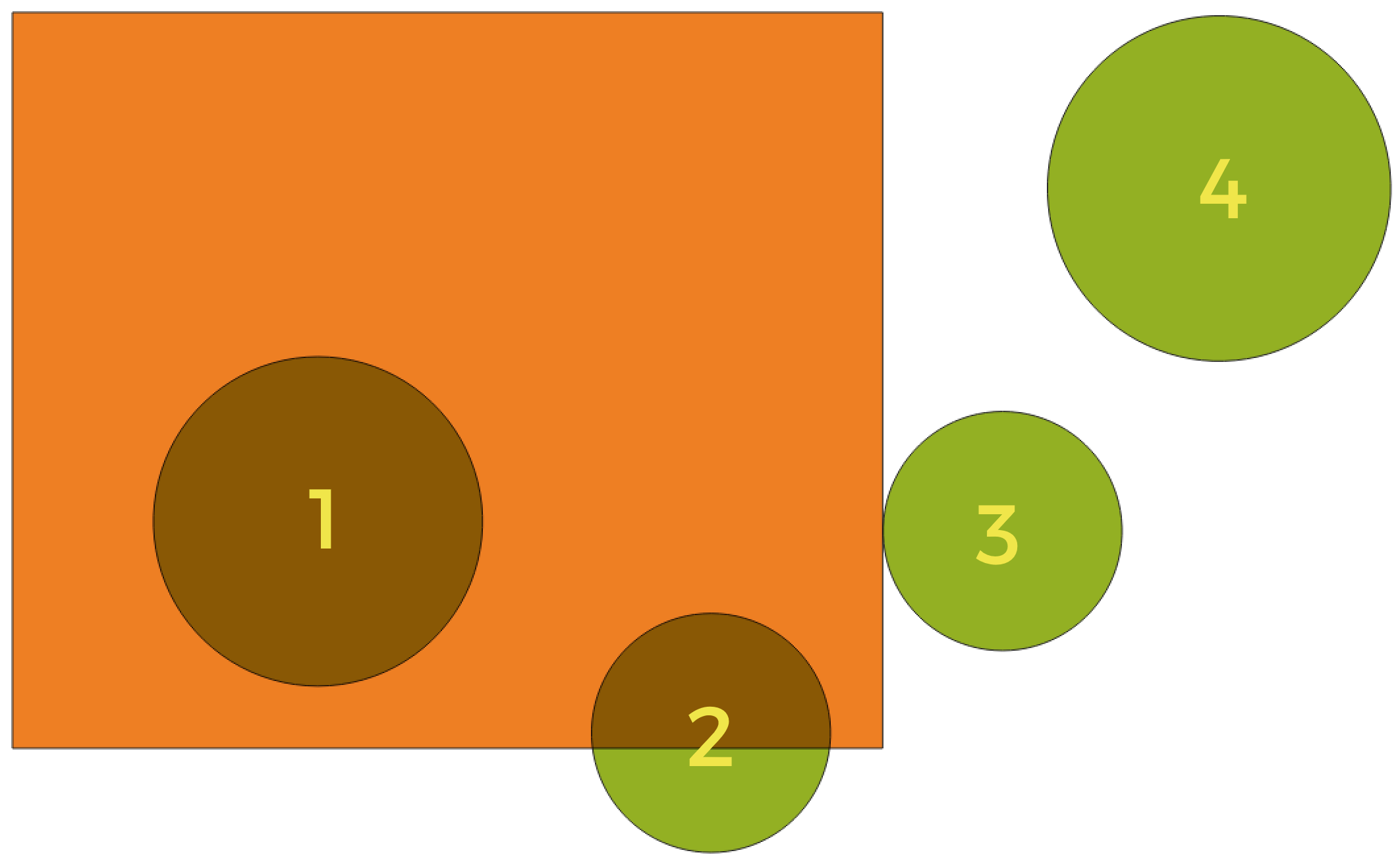
Geometric predicates are functions used to determine the spatial relation a feature has with another by comparing whether and how their geometries share a portion of space. They are often part of the options when doing overlay analysis, don't be hesitant to come back to this section when you run into them.
-
Intersect: Tests whether a geometry intersects another. Returns 1 (true) if the geometries spatially intersect (share any portion of space - overlap or touch) and 0 if they don’t. In the picture above, this will return circles 1, 2 and 3.
-
Contain: Returns 1 (true) if and only if no points of b lie in the exterior of a, and at least one point of the interior of b lies in the interior of a. In the picture, no circle is returned, but the rectangle would be if you would look for it the other way around, as it contains circle 1 completely. This is the opposite of are within.
-
Disjoint: Returns 1 (true) if the geometries do not share any portion of space (no overlap, not touching). Only circle 4 is returned.
-
Equal: Returns 1 (true) if and only if geometries are exactly the same. No circles will be returned.
-
Touch: Tests whether a geometry touches another. Returns 1 (true) if the geometries have at least one point in common, but their interiors do not intersect. Only circle 3 is returned.
-
Overlap: Tests whether a geometry overlaps another. Returns 1 (true) if the geometries share space, are of the same dimension, but are not completely contained by each other. Only circle 2 is returned.
-
Are within: Tests whether a geometry is within another. Returns 1 (true) if geometry a is completely inside geometry b. Only circle 1 is returned.
-
Cross: Returns 1 (true) if the supplied geometries have some, but not all, interior points in common and the actual crossing is of a lower dimension than the highest supplied geometry. For example, a line crossing a polygon will cross as a line (true). Two lines crossing will cross as a point (true). Two polygons cross as a polygon (false). In the picture, no circles will be returned.
Time to get your hands dirty! Move on to the 4th exercise to apply this new knowledge
Footnotes
-
http://gsp.humboldt.edu/olm/Lessons/GIS/06%20Vector%20Analysis%20Attributes/001_IntroOverlayAndBuffer21.html ↩
-
https://saylordotorg.github.io/text_essentials-of-geographic-information-systems/s11-02-multiple-layer-analysis.html ↩
-
https://docs.qgis.org/3.28/en/docs/user_manual/processing_algs/algs_include.html ↩ ↩2